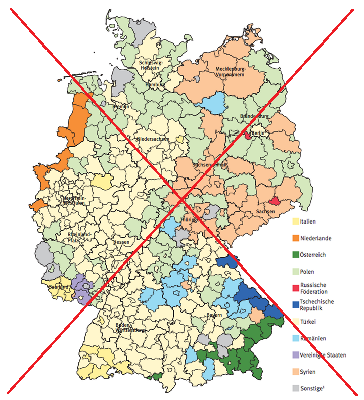
These days, more and more people move to where the work is. And for many people in Europe, that 'where' is Germany. I recently saw a map of Germany, that showed which country had the most foreigners living in each area. It was an interesting map, but I thought I might be able to make a few improvements...
Below is the original map from the article, and a list of some things I wanted to improve about it:
- The labels printed on the map are very difficult to read.
- Some of the colors are difficult to discern.
- The title is separate from the image file.
- There is no mouse-over text to see the individual county names & values.
- And the countries in the legend are in German (not a problem for those who speak German, but difficult for the rest of the world to understand).
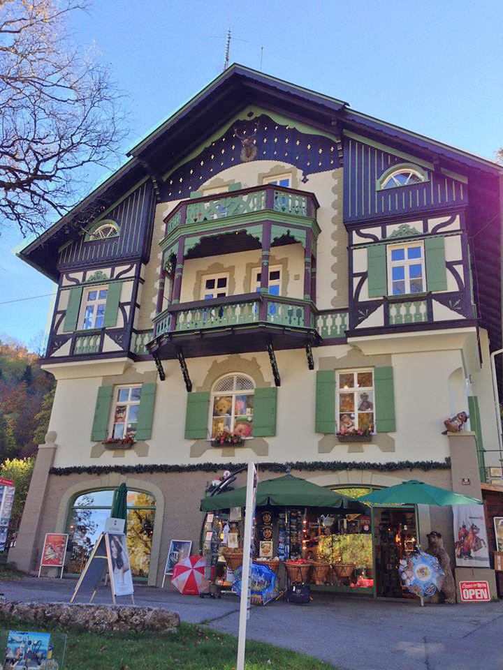
Before we move on to my new version of the map, here's a photo to get you into the mood for Germany. My friend Courtenay took this photo in the heart of the Black Forest on her recent visit. Here's a question to tie the photo in with the map - what is the predominant group of foreigners living in the Black Forest area? Wikipedia says the Black Forest is located in southwestern Germany, and from the map in the article (above), it looks like the foreigners living in that general area are probably from Turkey or Italy. Perhaps we can get a more exact answer with my new/improved map(?)
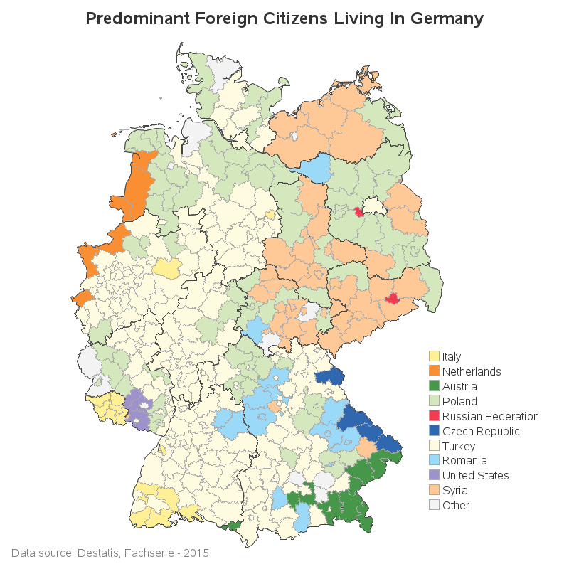
Here's a list of the improvements I made, and then an image of my new map (below):
- I removed the labels from the map, which gave it a much more clean look.
- For the colors that were difficult to discern (such as purple & gray), I adjusted them to be darker/lighter (eg, darker purple, and lighter gray).
- I include the title as part of the image file - now if someone copies the map image, the title automatically goes along with it.
- I added HTML mouse-over text, so you can mouse over each area and see the county & state name, and the predominant foreigners living there. (Click the map image below, to see the interactive version with the mouse-over text.)
- I changed the names in the legend to the English spelling (previously, I didn't have a clue that 'Vereinigte Staaten' was United States, and 'Sonstige' was Other!)
- I also made the county outlines lighter, and added a darker outline around the states.
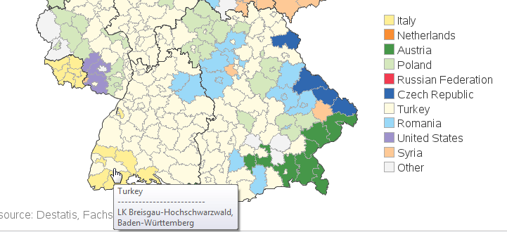
And now, back to the Black Forest question ... Wikipedia says it's in the state of Baden-Württemberg, and now I can easily see the extent of that state, using the darker black border (whereas before I just vaguely knew 'southwestern Germany'). The highest peak in the Black Forest is Feldberg, and that is in the district of Breisgau-Hochschwarzwald. I moused over the areas in southwestern Germany, and quickly found one with that name in the mouse-over text. Now I know that foreigners from Turkey are predominant in the area of the Black Forest's highest peak.
In addition to the map showing the predominant foreigners living in each area, it would also be interesting to plot the number, or percent, or per-100,000. I think a separate gradient shaded map for each country would be ideal. It's always best to plot the data in several different ways to more fully understand it.
And now for a 'fun' picture ... this one's from my friend Mark, who lives in Germany. It is a picture of a goat, riding on a sheep, in Heidelberg. I guess you could say the sheep is giving the goat a Lyft! ;-)


4 Comments
Robert,
Thanks for the great post! I was wondering where you got the data. I'd like to try the same with some other countries.
Brian
I'm not sure where to get the data in easily-usable form ... I had to 'estimate' the data for each area by looking at the colors in the original map (which was quite tedious!)
Hi Robert,
Nice job! Thanks for sharing. I am surprised to see where the US citizens can be found at..and there are more eastern Europeans and middle eastern than westerners?
I love Germany. My favorite country outside the USA.
I suspect there are a lot of US citizens in that area because of the military bases there:
https://en.wikipedia.org/wiki/List_of_United_States_Army_installations_in_Germany