Today is World Statistics Day, an event set up to "highlight the role of official statistics and the many achievements of the national statistical system."
I want to commemorate World Statistics Day by celebrating the role of the US government in data collection and dissemination.
Data analysis begins with data. Over the years I have bookmarked several interesting US government Web sites that enable you to download data from samples or surveys. In the last several years, I have seen several of these sites go beyond merely making data available to become sites that offer data visualization in the form of maps, bar charts, or line plots.
Here is my Top 10 list of US government Web sites where you can download interesting data:
- Bureau of Transportation Statistics (BTS)
Are you making airline reservations and want to check whether you plane is likely to be delayed? The BTS site has all sorts of statistics on transportation, and was used as the source for the data for the 2009 ASA Data Expo poster session. - Centers for Disease Control and Prevention (CDC)
Did you know that 4,316,233 births were registered in 2007 and that 40% of them were to unmarried mothers? Did you know that about one third of those births were by cesarean delivery? At the CDC you can explore trends and analyze hundreds of data sets by race, gender, age, and state of residence. - Environmental Protection Agency (EPA)
You can download data on air and water pollution, or find out if any industries near your home are incinerating hazardous waste. - Federal Reserve System (The Fed)
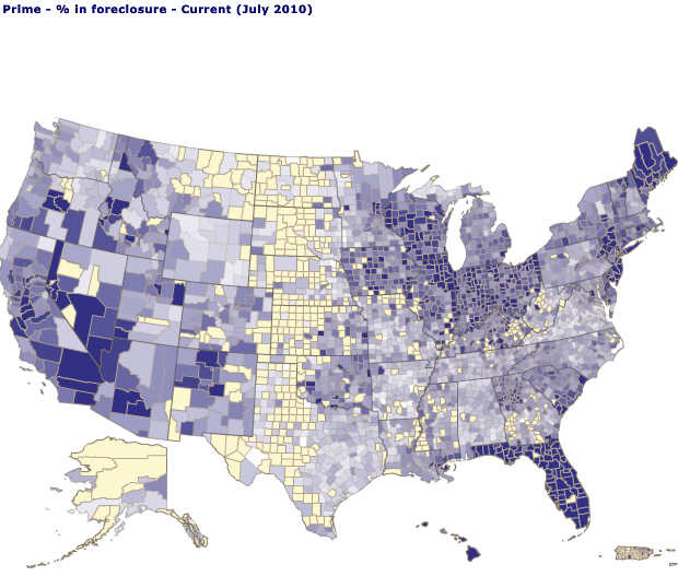
If you want data on the US economy, this is a great place to begin. A server to build custom data sets enables you to create a map of the percentage of prime mortgages that are in foreclosure. Notice the regional variation!
- My NASA Data
The NASA server at this Web site enables you to create your own customized data set from 150 variables in atmospheric and earth science from five NASA scientific projects. This type of data was used for the 2006 ASA Data Expo. - National Oceanic and Atmospheric Administration (NOAA)
Interested in subsurface oil monitoring data from ships, buoys, and satellites in the aftermath of the Deepwater Horizon spill? More interested in a historical analysis of hurricanes? All this, and more! - National Center for Atmospheric Research (NCAR)
Everything you wanted to know about weather and climate in North America and beyond. Download data about temperatures, precipitation, arctic ice, and so on. - US Department of Agriculture (USDA)
Check out the very cool Food Environment Atlas. The Economic Research Service (ERS) branch of the USDA disseminates many data sets on land use, organic farming, and other agricultural concerns. Several USDA researchers use SAS/IML Studio and regularly present research papers at SAS Global Forum. - US Census Bureau
Do you want to know where people live who satisfy one of hundreds of demographic characteristics, such as the percent change in population from 2000 - 2009? I have two words for you: "thematic maps."
- US Geological Survey (USGS)
Data on scientific topics such as climate change, erosion, earthquakes, volcanoes, and endangered species. What's not to like?
Did I omit YOUR favorite government site that provides raw or summarized data? Post a comment and a link.

1 Comment
I'm a regular user of your top 9, but the USGS site has never made it into my browser. I'll be sure to check it out!
I work for a small non-profit called HealthLandscape, and we manage a site (HealthLandscape.org) that compiles public-use data into a single mapping application. It's a pretty nifty tool to play around with, and many of the data that you mentioned are included and available for mapping. There's no cost, but you do have to register an email address. Users can create their own thematic maps like the ones you've included in your post.
We're about to debut HealthLandscape V3, and I'm very excited about it. It will be much more user-friendly and more interactive.
Thanks for letting me share, I'm a long-time SAS user and a big fan of the blogs.