With all the recent talk about some people wanting to move from the US to Canada, I got to wondering how cold, and how far north Canada is. And after a few Google searches, I was surprised to learn that 27 US states are actually farther north than the southernmost point of Canada! This seemed like a good thing to show & prove on a map...
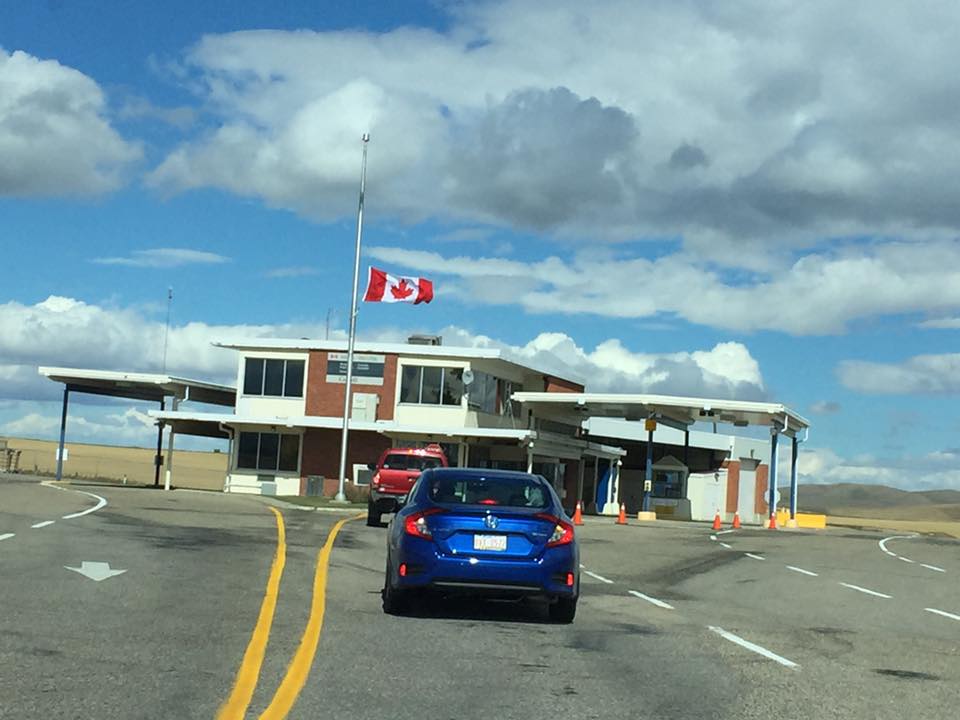
But before we get to the map, here's a photo from my friends Joy & Erik, to get you into the mood for a blog about Canada. This is the border crossing as they were entering Alberta (from Montana), on their way to see the Canadian part of Glacier National Park. These guys travel a lot, and this was one of their 'short' trips from NC ... only about 2,350 miles away! (They didn't move to Canada, by the way - just visiting!)
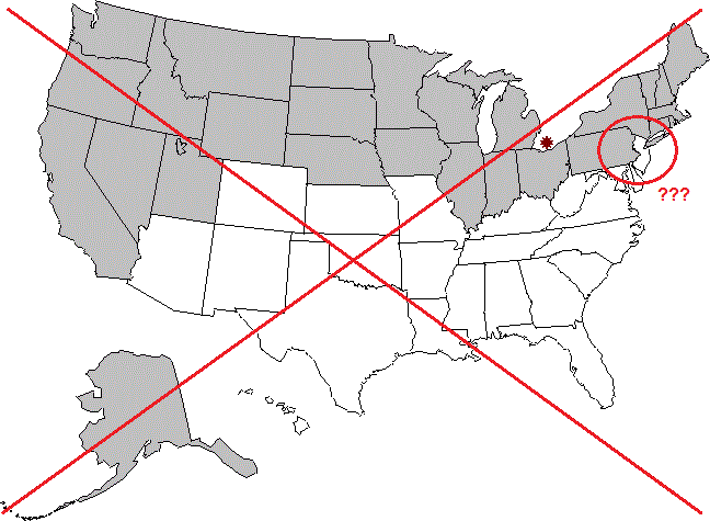
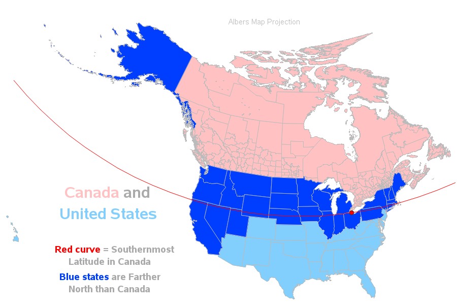
Now, how about those 27 US states that are farther north than Canada?!?... Below is one of the many maps I found in my web search on that topic. They placed a marker at the southernmost point of Canada, and the US states which are at least partially north of that point are shown in dark gray. I guess their map covers the basics, but here is a list of the things I would like to improve about it:
- Canada is not actually shown on the map.
- Alaska is shown south of the US, although it is geographically to the north.
- The map doesn't contain descriptive titles (you have to read a lot of text in the article to figure it out).
- And, although they mark the southernmost point in Canada with an '*', it is not evident exactly where that latitude line runs across the US (for example, the northern tip of New Jersey looks farther north than the southern Canada marker, in this map).
Let's see if we can do better...
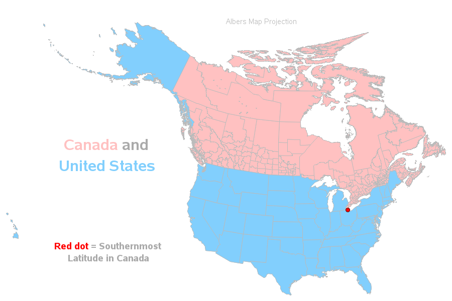
I started my map by adding Canada, leaving Alaska in its proper geographical location, and adding some descriptive labels to the map. I used the following SAS SQL code to determine the southernmost point in Canada (calculated from the map data), and save it into a dataset so I could annotated it on the map as a red dot. I also saved the lat/long values of this coordinate as SAS macro variables, so I could easily use them later in the code to do other things (such as calculate points along the line). In case you're curious, the minimum point in Canada is at approximately latitude 41.7 degrees north.
proc sql noprint;
create table minpoint as
select unique *
from mapsgfk.canada
having lat=min(lat);
select unique lat into :min_cany separated by ' ' from minpoint;
select unique long into :min_canx separated by ' ' from minpoint;
quit; run;
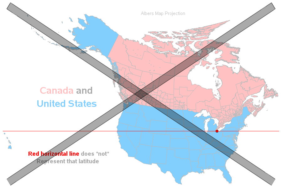
Looking at the map above, your instincts might tell you to visually draw a horizontal line at latitude 41.7, and see which US states are at least partially above that line. But that is the wrong thing to do! (Notice that New Jersey crosses this simple horizontal line.)
Why was that wrong?
The Earth is a globe/sphere, and in order to view a portion of it on a flat page we have to 'flatten' it out. And to do that, we have to stretch some areas. We do this flattening & stretching of the map using various projection techniques - the above map was flattened using the Albers projection, centered on the 48 contiguous US states. If you use the projection on the map, you also have to use the projection on the points along the latitude=41.7 line. In the map below, I use the Albers projection on both the map and the line. With the properly curved/projected line, it is now easier to see that New Jersey is now totally below that line.
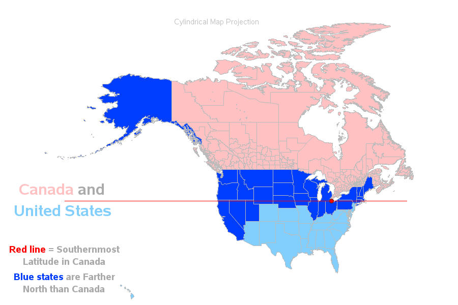
You might be thinking "projection techniques and curved lines of latitude - ugh!" My map-geek friends understand this kind of thing, but can't we create something simpler, that will be intuitive to non-map-geeks? Isn't there some way we can just use a simple/straight/flat line? I'm glad you asked! If you use the cylindrical projection, the lines of latitude do come out that way! The map might look a little 'squished' compared to what you're used to seeing, but I think the straight line makes it a lot more intuitive that the line is dividing things into north and south. Here is an alternative version of the map, using the cylindrical projection.
What about you? - Do you live farther north than the southernmost point in Canada (latitude 41.7 degrees north)? And if so, do you consider your climate cold? Feel free to answer this question even if you're not in the US - latitude 41.7 degrees north extends all the way around the globe, of course! :-)

46 Comments
The part of Canada that dips on the eastern side of the map, is also our most densely populated area. An estimated 72% of Canadians live below the 49th parallel which is the US/Canada border in the west. So not only do many states stretch above Canada's most southern tip, many Americans live further north than the majority of Canadians.
Title is misleading. It should say: “27 states are farther north than PARTS of Canada”. Your title implies that entire states are north of Canada when only Alaska is of course.
Ay, here in Chicago, north of Middle Island! Well, most of Chicago. :P
It never ceases to amaze me how many Americans have no clue about this. I tell them that I'm further south than they are, and they don't believe me. I'm near Windsor in Ontario.
Geography (and globe/map concepts in general) are definitely not a strong-point for many people! :)
It doesn't amaze me, I have to say. Some years ago it was reported that 85% of Americans couldn't identify Vietnam on a map (this was only a few years after the conclusion of the Vietnam War). I've had a long-time Bostonian ask if Nova Scotia was a separate country, and a Medical Degree student say, "Oh, yeah - Africa...Where is that?" Another Bostonian said he'd never been "out West"...Thinking he meant California, it turns out he meant the Berkshires in western Massachusetts. I met an elderly couple near Niagara Falls. The husband was very proud when he said, "We're a long way from home! We're from Pennsylvania!" He may have driven as little as 100 miles or so. When I said I was from Sydney, Australia it was as if I'd said I was from a planet in a totally different galaxy - I simply received a look of blank incomprehension. Finally, several American friends have expressed over the years the desire to see the 'whole of Australia'...in a 2 week visit. "Um...do you realise it's the same size as the 48 contiguous states?" No, they didn't realise that. I suppose none of this is particularly surprising. According to some stats I saw recently, only 4% of Americans held passports in 1990. 4%! It seems a bafflingly low number. It's now well over 40%, apparently, so I guess there's some hope. I have more stories but I'll leave it there. Thankyou for your interesting blog on this topic.
My god, why would you want MORE of us tromping around?
While we were visiting Martha's Vineyard, a local asked where we were from:
"Ohio."
"Iowa?"
"No, Ohio."
"Ohhhh. Idaho."
Sheesh!
Do note, though, in 1990 there were several places you didn't need a passport - in the 90s I went to Canada and Barbados without a passport.
Didn't the US supposedly send an invitation to the Swiss navy for the opening of the Panama Canal?
You could still get into Canada from US with out a passport until 2009
I live in Niagara Falls Ontario Canada and still get the do you drive cars up there as well as deer in our front yard. Ok the latter is true. My point being that even in this day and age we are still a mystery. Apparently! 😉
Toronto Ontario (Canada's most populated city) is further south than 7 US State capitals; 1. Juneau Alaska, 2. Olympia Washington, 3. Helena Montana, 4. Bismarck North Dakota, 5. St. Paul Minnesota, 6. Montpelier Vermont, 7. Augusta Maine.
Interesting bit of trivia - thanks!
What part of the "South" are you from? Despite your geekie computations of how far north Canada actually lies, the truth is that Middle Island Ontario,Canada, 41.70 N. lies approx. 520 miles south of the 49th latitude line, which is approx. 65 miles north of N.Y.C., {less for New Jersey} and it lies south of approx 31% of the contingent U.S.A.
as a canadian, I would have to disagree with "27 US states are farther north than Canada" because what is being are considered "Canada" is just a very small stretch of land, and even so, that being our warmest sector...
But "At least a portion of 27 US states is farther north than the southernmost point of Canada" doesn't sound nearly as exciting! ;)
But it's not about North versus South when it comes to heat. West versus East is a far larger factor, and the BC west coast rarely ever sees snow, people play tennis in Vancouver parks while New Yorkers shovel their cars out...every winter. Even Juneau, Alaska is often far warmer than many lower US cities.
Interesting! Does the west coast of Canada get warmer weather brought in by the Pacific Ocean currents?
Actually...I am a weather buff. And parts of Canada frequently register warmer concurrent winter seasons than even Dallas-Fort Worth (Texas)! For example - every few years (or so?), the town of Shirley, BC, Canada registers a warmer concurrent winter season than Dallas-Ft. Worth. It's already happened several times in the new millennia!
Robert Allison:
Are you more surprised at Canada's southern latitudes? Or...more surprised at the fact that some parts of Canada occasionally register warmer concurrent winter seasons than Dallas-Ft. Worth area?
Interesting!
In fact - the two(2) major urbanized areas (i.e. cities - NOT towns) on Canada's West coast NORMALLY register warmer winters than many-a-southern city including the likes of world-famous Nashville, Tennessee (not normally warmer than Dallas-Ft. Worth, though!).
A meteorologically warmer winter season is defined as a warmer mean temperature averaged between day-AND-night through the three(3) winter months - December; January; and February. Do the math(below), and you'll discover that the two(2) major cities of the region (Vancouver & Victoria) both register warmer winter seasons than Nashville, Tennessee. My data source is NOAA (a USA Government Agency), as follows...
Nashville, Tennessee
https://www.google.com/search?safe=active&sxsrf=ACYBGNTA3j-Qsi2mnDzNkif3bWlWSil0Og%3A1577546839483&ei=V3QHXsmWHcmLtAbA5LOYCw&q=nashville+average+winter+temps&oq=nashville&gs_l=psy-ab.1.0.35i39j0i67j0j0i131j0l4j0i131j0.115701.117419..120828...0.1..0.109.752.8j1......0....1..gws-wiz.......0i71j0i131i273j0i131i67j0i273j0i20i263.IO81xLqkAHk
Vancouver, Canada
https://www.google.com/search?safe=active&sxsrf=ACYBGNQwMrHW-EYlzCxzvO2zY9lDUzI-qg%3A1577546961312&ei=0XQHXoPJEsmstQbb0brgDg&q=vancouver+average+winter+temps&oq=vancouver+average+winter+temps&gs_l=psy-ab.1.0.35i39.27194.29127..35161...0.1..0.136.751.8j1......0....1..gws-wiz.......0i71j0i7i30j0i8i7i30j0i8i30j35i304i39.nDh5tFwOzdA
Victoria, Canada
https://www.google.com/search?safe=active&sxsrf=ACYBGNShM0Ldn0ts_eZ7l7Vn4T4ZOicOGQ%3A1577546997676&ei=9XQHXqnvKJWLtAa-mK7gCw&q=victoria+average+winter+temps&oq=victori+average+winter+temps&gs_l=psy-ab.1.0.35i304i39.41552.42884..45221...0.1..0.96.546.7......0....1..gws-wiz.......0i71j0i7i30j0i8i7i30.6rjkJg3TV2o
Since you found my last message interesting, here’s another interesting comparison! I think somewhere it said you were in Raleigh, North Carolina?
Well, as it turns out, the residents of Canada’s mildest city – Victoria, Canada – NORMALLY enjoy warmer winters than you do in Raleigh, North Carolina.
Specifically, as detailed below, the mean winter temperature in Raleigh, North Carolina is 43 degrees (versus a slightly warmer 44 degrees in Victoria!).
I bet you would have never guessed there are resident Canadians that normally enjoy warmer winters than you do in Raleigh! Anyway, the historical temperature statistics are as follows (source is NOAA)…
Raleigh, North Carolina
https://www.google.com/search?safe=active&biw=1280&bih=913&sxsrf=ACYBGNSNDmWRktQQOC1YqRkGbcIH7ZM5-Q%3A1578274504335&ei=yI4SXtaEFJD-tAXp4angBw&q=raleigh+north+carolina+average+winter+temps&oq=raleigh+north+carolina+average+winter+temps&gs_l=psy-ab.3...17949.25130..25432...0.0..0.92.1577.22......0....1..gws-wiz.......0i7i30j0i8i7i30j33i10._gUeFbu9NTA&ved=0ahUKEwjWiMHZ6u3mAhUQP60KHelwCnwQ4dUDCAs&uact=5
Victoria, Canada
https://www.google.com/search?safe=active&biw=1280&bih=913&sxsrf=ACYBGNSthNYo_28goAgzgQ0tvtkYIElWgg%3A1578274530824&ei=4o4SXu75McLAsQXF4pqwAg&q=victoria+average+winter+temps&oq=victoria+average+winter+temps&gs_l=psy-ab.3..35i39.34975.36180..37226...0.1..0.154.742.7j1......0....1..gws-wiz.......0i71j0i7i30j0i8i7i30j35i304i39.hBll20ILlIE&ved=0ahUKEwju8pHm6u3mAhVCYKwKHUWxBiYQ4dUDCAs&uact=5
Also interesting! (I might have to graph some of this data!) :)
Thanks sooooo much for offering to graph some of this data! You're a very powerful ally (with presumably MUCH more of an audience than I can ever get?). As a weather-buff, I enjoy revealing weather facts that are surprising to many people!
LAST 2 MESSAGES
I apologize, in advance, for taking up your time. These will be my last 2 messages for this thread (although I will, no doubt, follow your articles and occasionally message on future threads?).
I would like to take a little bit of time, as a self-proclaimed ‘weather expert’, to assist you with the graphical data that is revealed in my links.
As you know, it CAN snow in Raleigh (as it can in Victoria, Canada). It’s just that it’s pretty rare for residents of either place to wake up to snow on any given winter morning.
From the graphs (in my previous links), you can see that the average annual snowfall in Raleigh amounts to 5 inches (Victoria = 6.5 inches) – even though both cities have an average of 0 annual DAYS of snow.
Zero(0) annual days of snow means that it is unlikely to snow on any 1 of 365 days of any given calendar year!
The annual average snow inches are warped by the comparatively snowy days (i.e. one large snow-storm the odd year that clears up in a week and all is back to normal!).
The truth is that half the winters (in both cities) transpire completely snow-free!
FINAL MESSAGE
Pièce de résistance,
There’s a Provincial Park that’s only 6 miles from Downtown Victoria that’s arguably Canada’s mildest and most snow-free location (majority of winters transpire completely snow-free!). Its Januarys are historically (normally) warmer than the Januarys in the northern suburbs of the Dallas-Ft. Worth Metroplex.
For example – Frisco is a popular city-suburb that’s officially part of the Dallas-Ft. Worth Metroplex count and it has an historic January mean temperature of 44 degrees, as do most of the other northern suburbs of Dallas-Ft. Worth - versus a slightly warmer 45 degrees for the Canadian Provincial Park (Raleigh average January temperature of 40 degrees is noticeably cooler than both!), as follows…
Frisco, Texas
https://www.google.com/search?safe=active&sxsrf=ACYBGNTK2PiM-pt5mHoZSPlrT8TTafBfCg%3A1578330048967&ei=wGcTXsfKOsKKtQXEwpzwCw&q=frisco+average+winter+temps&oq=frisco+average+winter+temps&gs_l=psy-ab.1.0.35i39.98349.99562..103045...0.1..0.92.483.6......0....1..gws-wiz.......0i71j0i7i30j0i8i7i30j35i304i39.o6jwXSIvMxY
Discovery Island Marine Provincial Park, Canada
https://www.google.com/search?safe=active&sxsrf=ACYBGNRqWKo1oicuZ0eaJZD5RT0la0CGYQ%3A1578330153343&ei=KWgTXu_IFMGosgXwwajYBA&q=discovery+island+marine+Provincial+park+average+winter+temps&oq=discovery+island+marine+Provincial+park+average+winter+temps&gs_l=psy-ab.3..35i39.46326.55318..56130...0.1..0.188.3381.34j5......0....1..gws-wiz.......0i71j0i7i30j0i8i7i30j35i304i39.yWsWHjFUqP0&ved=0ahUKEwivgYOBuu_mAhVBlKwKHfAgCksQ4dUDCAs&uact=5
You must be from Alberta! lol. Listen....I am a proud Canadian living in Southwestern, Ontario near Windsor, and believe me, we are very much south of dozens of states! Our weather is usually quite good, not nearly as bad as the western provinces save possibly the extreme west coast of BC.
are the grey border lines inside if Canada supposed to represent provinces?
They are one level more granular than provinces. The mapsgfk.canada_attr dataset labels them as "Census Divisions".
very cool thank you!
This is mildly interesting, but "Blue states farther North than Canada" is very poor wording. That includes California, of all states, that extends as far South as the border with Mexico!
What are shown are states of which "some portion" lies farther North than the most southern point in Canada.
Yes, Jo .... but Robert made that quite clear in the text that he wrote, didn't he? I am not sure why you feel the need to point something out that has already been explained in detail.
This stuff is neat but latitude doesn't tell the whole story on weather.
I live in Toronto, Canada, at about 43 degrees N. The next largest city in Canada is Montreal -- it's at about 45 degrees N but is much cooler than Toronto, and much snowier in the wintertime. Toronto "benefits" by being on the shore of Lake Ontario (basically an inland ocean comparable in size to some small European countries) which moderates our temperature. Vancouver is at 49 degrees N but sits right on a gulf of the Pacific Ocean, and has very mild winters with almost no snow.
I live in the "banana belt" of Ontario....in Chatham-Kent. Our winters are not nearly as bad as Toronto's, and I'm 3 hours southwest of the GTA (Greater Toronto Area for those Americans reading this)
Much of Europe, including my home town of Zurich, Switzerland at 47.38N, is farther North than the Southern tip of Canada. However, thanks to the gulf stream, our climate is very mild compared to Canada. We still have good hockey, though. :-)
Nowhere near as good as Canadian hockey!
My first thought was the follow-up map: Which European countries are farther North than Canada?
But a quick look at the map revealed a rough answer: Greece and possibly Portugal. (I am not sure what kind of projection was used on the map I checked)
I would have guessed Pelee Island, but thanks to Wikipedia, the red dot is probably Middle Island. It's a short boat trip from Cleveland.
I wonder how the states below the red line were also colored blue. How are they farther north than the southernmost point in Canada. Please explain! This map was very interesting!
The southern states are 'light blue' rather than blue :)
I meant to ask about California, Nevada, Utah etc that are colored blue (not light blue). Thank you for responding!
Believe it or not, at least a portion of each of those states are farther north than the southernmost part of Canada (ie, they're at least partly above the red line)! :)
Got it, thank you!
California was the most surprising to me!
and a small part of California is south of a small part of Mexico!
So California is both north of Canada and south of Mexico.