We just had the big July 4th holiday weekend here in the US. And as with many holidays, there was a lot of drinking. Which got me thinking/wondering ... which counties do not allow alcohol to be sold (ie, which counties are 'dry')? And it seemed like a question that might be best answered using a map!
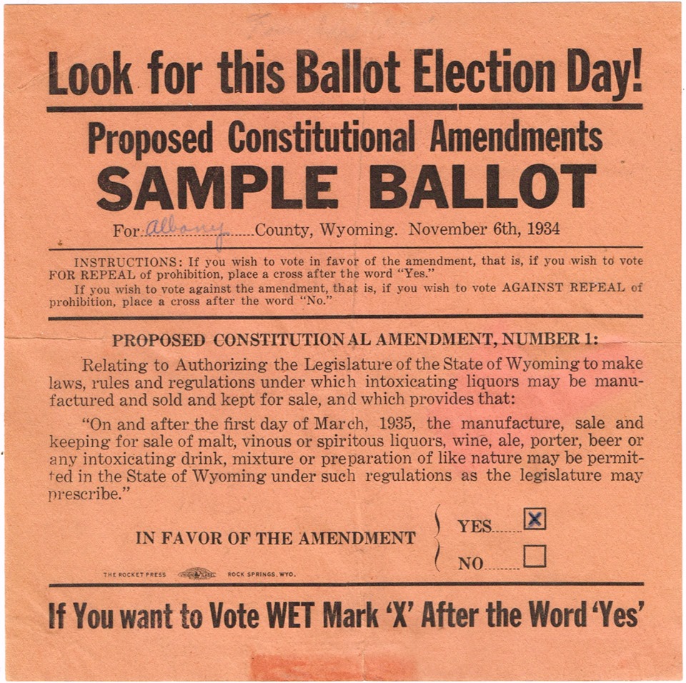
But first, here's a little something to set the mood for a blog about selling (or prohibiting the sale of) alcohol. This poster is from my friend Erik, who collects and sells vintage brewery advertising. (Pretty cool, and right on-topic, eh!?!)
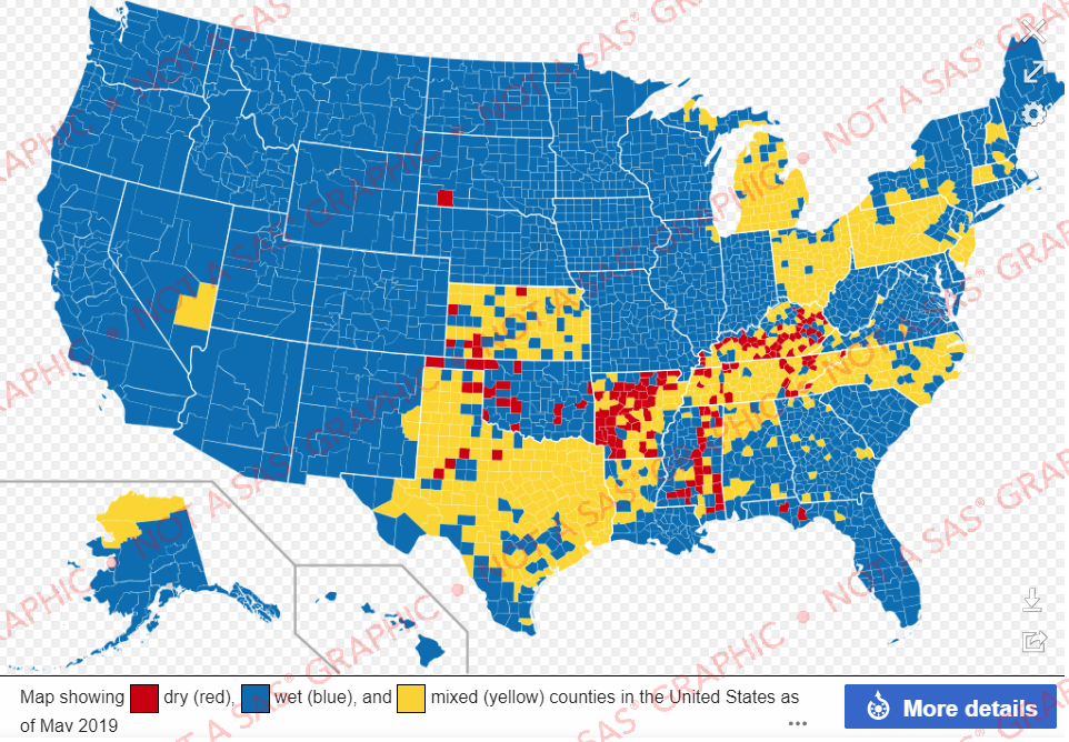
Wikipedia's Map
Before I started working on my own map, I decided to do a few Web searches to see if there was already one out there. And I quickly found this one on a Wikipedia page - but I didn't really like it. On the main page, the map was too small to see any detail. And if you clicked on it to see the full-size map, it has a transparent background ... which shows up as checker-board gray and white in my browser (which is very visually distracting). Also, their map had no mouse-over text to show the county names. And the map seemed too 'busy' with with every county having an attention-grabbing color.
My Map
So I decided to create my own map, and make a few improvements/enhancements. Below is a screen-capture of my new version. Click it to see the interactive map:
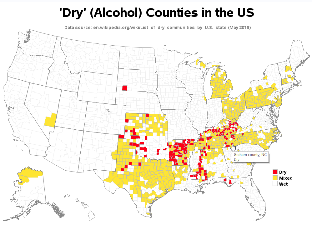
How many differences/improvements did you see in the new map? Compare your mental list with my list, below to see if you caught them all ...
- Since the purpose of the map is to show 'dry' counties, I de-emphasized the wet counties in my map. Instead of making the wet counties blue, I made them white.
- My map has a solid white background, rather than the transparent background (which showed up as as distracting check-board in the Wikipedia map).
- Rather than ordering the legend "dry, wet, mixed" I ordered it "dry, mixed, wet" - this seems like a more logical/intuitive order.
- I include a proper/traditional title at the top of my map (whereas the Wikipedia map tries to use the legend as the title).
- And when you click a state in my map, it drills-down to the section providing details for that state on the Wikipedia page.
How'd he do that?...
Here are some technical details about how I created my map using SAS software. (If you'd like to see all the nitty-gritty details, here's a link to the full SAS code.)
- First I created a county map, and colored the counties as desired.
- I then used annotate to overlay the state outlines on the map.
- I used values 1, 2, and 3 to code my values for Wet, Mixed, and Dry in the data, and then created a user-defined-format to make them print as the text values in the legend (this sorts the legend in the desired numeric order, even though it's printing the text values).
- I used the html= option to point to a variable in my data where I had encoded the mouse-over text (encoded as HTML title= tags) and the drill-down (encoded as HTML href= tags) for each county.
If you liked this topic, click here to see more SAS blogs about alcohol data!


6 Comments
Cook County Illinois being dry is about as likely as the county Las Vegas occupies being dry. My conclusion is Wikipedia's "mixed" definition is that: MIXED.
In the map, drill-down to Illinois, and then Wikipedia provides the following details: "The village of South Holland has been a dry municipality since it was founded by Dutch Reformed immigrants in 1894.[80] In accordance with the state liquor law (see overview), South Holland bans the sale of alcohol by not issuing licenses for any business to sell alcohol in the community. The possession, consumption and transport of alcohol are all permitted in South Holland. Other villages in Illinois' Cook County, such as Oak Park and Evanston, were once dry communities, but have since re-allowed the sale of alcohol, though these villages still tend to have tougher regulation on alcohol sales than the rest of the county." 🙂
There's a lot of yellow on the map for Ohio that is not explained in the Ohio section of that Wikipedia page.
Rob,
I really enjoy your work on maps. In your example, you reference "RobsMaps". I have been trying to put together a family of US maps similar to yours. Do you have a code example of making the County map you show from the mapsgfk set included in SAS? Thank you again for all your great examples and topics.
Here's the code I used to create my county map: http://robslink.com/SAS/democd97/uscounties_info.htm
Rob,
This is perfect. Thank you very much for sharing how you scale and move the states into alignment.