I suppose we've all been watching Hurricane Irma rip through the Caribbean like a giant buzzsaw blade, with wind speeds over 180mph. This is one of those rare Category 5 storms. But just how rare are Category 5 hurricanes? According to the Wikipedia page, hurricanes with wind speeds >=157mph are considered Category 5. So let's dig up some data, and see how many hurricanes we've had in the Atlantic with those kind of wind speeds ...
After a bit of digging, I found a good repository of data about past hurricanes on the weather.unisys.com website. I wrote a bit of code to read and parse the data into a SAS dataset, I then plotted all the Atlantic hurricane paths on a map, and made the line segments bright red where the wind speed fit the Category 5 description. This provides a good general idea of how often they occur, and also where they occur:
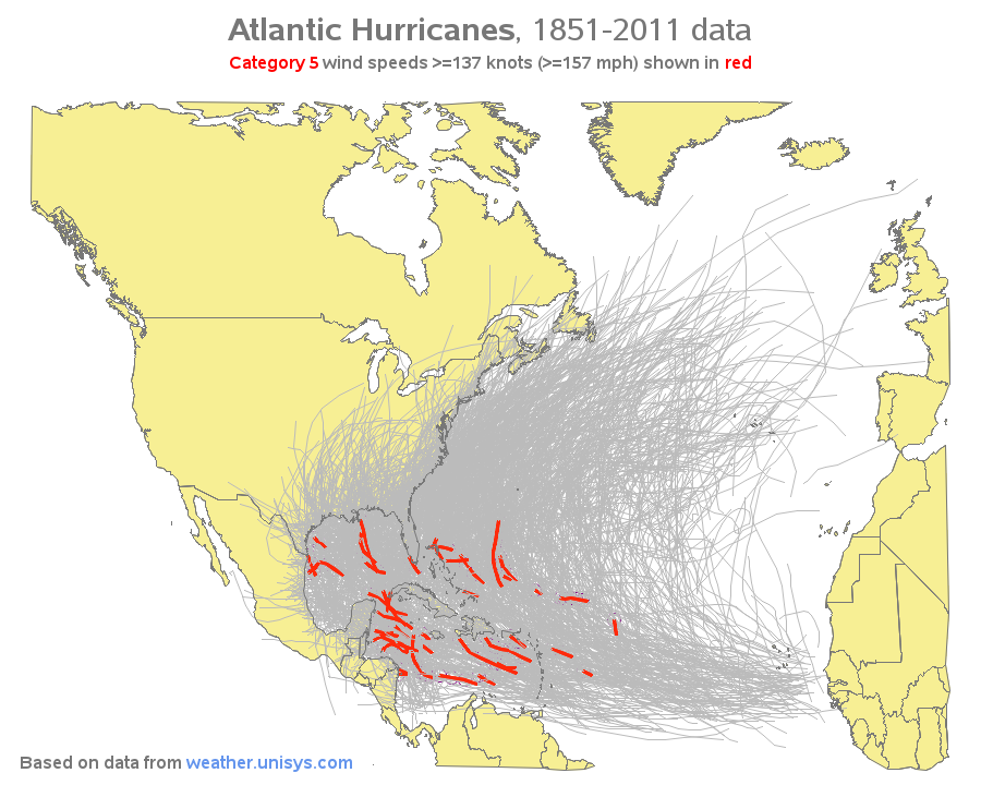
Click the map image above to see the full-size interactive version of the map, with HTML mouse-over text showing the hurricane names for the red (Category 5) segments. Here are some technical details about the code I used to create the map:
- I created the map using SAS/Graph Proc GMap.
- I projected the map using Proc GProject, and then saved the projection parameters using the new parmout= option. I was then able to project the hurricane paths separately, using GProject's parmin= option. (Before the parmout/parmin parameters were added, I would have had to combine the map and hurricane paths, project them together, and then separate the results into two datasets again - the new functionality makes things a lot easier!)
- The hurricane paths were drawn using simple 'move' and 'draw' Annotate functions.
- I first plotted the land areas (choropleth map), then overlaid (annotated) the hurricane tracks (making sure the 'red' ones were on top so they'd be visible), and then overlaid the country border outlines on top again so they would be visible.
- Since lines don't support mouse-over text, I annotated circles with the mouse-over text along the red hurricane paths. I drew these circles behind/before everything else (using when='b'), so they would be 'invisible'.
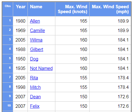
I also placed a table below the map. The table shows 34 Category 5 Atlantic hurricanes, based on more than 150 years of data. I've included a snapshot image of a portion of the table below - you can click the snapshot to see the full interactive table, and then you can click each hurricane name to launch a Google search for more information.
Note that the speeds in the Unisys data are rounded to 5-knots, so there might be a few hurricanes with Category 5 wind speeds that didn't get picked up by my query ... but I think it gives you a pretty good idea how rare they are, and where they typically occur.
Are any of my blog readers in the forecast path of Hurricane Irma? How about any of the previous Category 5 hurricanes? Feel free to add a comment to tell us your "hurricane story"!
Map of Category 5 hurricanes in the US! Click To Tweet


7 Comments
You'll find the original dataset here: https://www.ncdc.noaa.gov/ibtracs/index.php?name=ibtracs-data. This should be more up-to-date too.
Ahh! - Thanks for the info!
This is a great piece of work. What struck me was the density of your grey lines. Can you confirm that it is the the result of discrete lines. Also, is each Hurricanes entire path plotted and does the plot end when it drops off hurricane speeds?
You can see individual lines a little better on this one, where I plot them in multiple colors...
http://robslink.com/SAS/democd39/hurricanes_typhoons.htm
This graph clearly shows that the storms don' between the hemispheres. So one can pick a location guaranteed to never have a hurricane!
I believe the data is also included where they are tropical depressions and tropical storms.
With the speeds in knots rounded to multiples of five, I would at least round the MPH values to the nearest integer, or maybe even x5's too. The decimal digits make them seem more accurate than they really are.