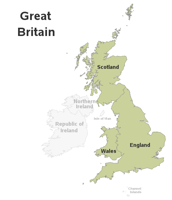
With the recent vote for the United Kingdom to leave the European Union being all over the news, I was a bit embarrassed to realize I didn't know exactly what areas are (and aren't) considered part of the UK.
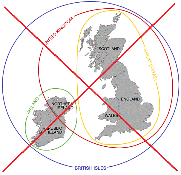
After a few Google searches, I found the following map on the brilliantmaps.com site, which I thought explained things in a nice simple way. But as I did more research, I found that Isle of Man (the island just off the northwest corner of England) was not really part of the UK or Great Britain. Therefore, although this map is simple and elegant, it is also wrong.
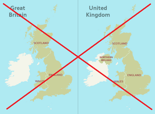
After a bit more searching, I found a set of maps on the ordnancesurvey site which did a much better job of showing the correct geography. They used a separate map for each grouping (see screen capture below for two of their three maps).
But there are still a few things I didn't like, or would have done a little differently:
- They didn't label the areas that were not part of the grouping being highlighted.
- They didn't show borders in the areas not being highlighted (for example, between the two areas of Ireland).
- They used a blue background, which people will think is water - but not all the area shown in the map is water (for example, along the southern edge would be land).
- The small white islands (at the bottom of the map) didn't show up well against the light blue background.
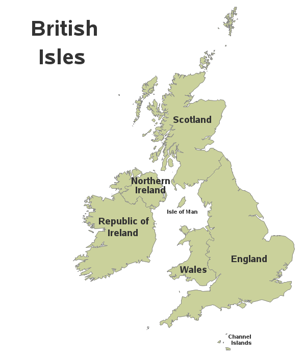
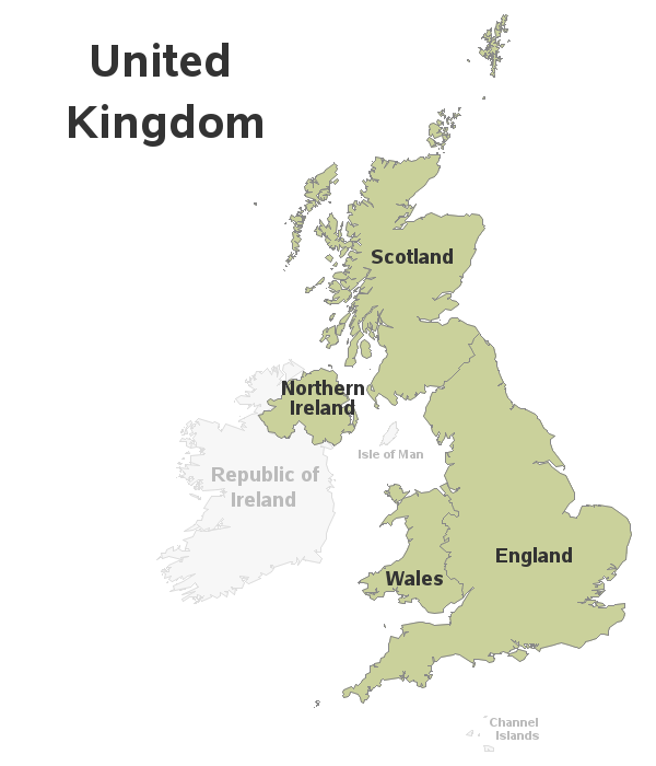
So I set about creating my own map to show things in a more clear and informative way. There wasn't a SAS base map that had all these exact geographical groupings, so I had to create a custom map. I combined three maps (UK, Ireland, and Isle of Man from the world map), and then used Proc Gremove to get rid of some (but not all) internal borders in the UK map. I created an annotate dataset to place country labels in the desired location (and size). I used note statements to place the title in the upper-left corner and share what is technically 'map area,' instead of using the title statement which only places titles above the map.
Here are my three maps:
And the big question - which of these areas does the recent 'Brexit' vote impact? (Just the 'UK' areas?) And do you think the area(s) will change before everything is finalized?
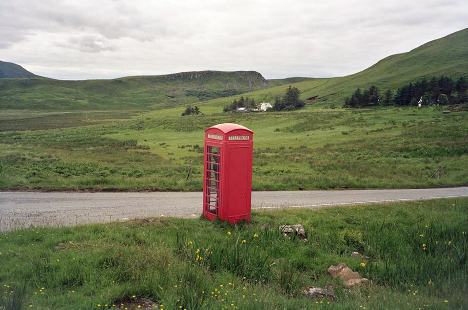
Now for some fun trivia ... My friend Margie has done quite a bit of traveling. Where did she take this picture? (you can leave your guess in a comment!)


9 Comments
Hello,
Thank you for this post. I'm falling in love with the British Isles.
And I'm interesting by trying to do the same with the French country, la France.
Or could you make the same with la France ?
Can you tell me if I can get your code, please ?
Amazigh.
Glad you like it! - Here's a link to the SAS code I used:
http://robslink.com/SAS/democd87/british_isles_info.htm
For those of you curious, Margie took the picture on Isle of Skye (an island on the northwest side of Scotland). https://en.wikipedia.org/wiki/Skye
Here's some trivia: The Isle of Man has it's own flag, and it is one of the coolest, most unusual, flags in the world. It is right up there with the flag of Siciliy, where my dear old grandma came from.
Thanks for the...um...clarification. Good to see the UK (and region) laid out like this. Plus Tour de France fans can now see exactly where Mark Cavendish (pro cyclist sprinter) is from (Isle of Man).
nature reserve
Which nature reserve?
Ok - I'll make it easier for you ... can you first guess whether it's in England, Scotland, Wales, or Ireland? :)
Only the UK areas plus (and this surprised a lot of people even over here) Gibraltar which is a British Overseas Territory and part of the EU https://en.wikipedia.org/wiki/United_Kingdom_European_Union_membership_referendum,_2016#Eligibility_to_vote
Ahh! - Interesting bit of detail!